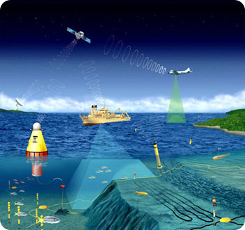
 A graphical depiction of many types of observing systems used to collect ocean data. Credit: National Oceanic & Atmospheric Administration.
The oceans are constantly changing. Sunlight warms them, storms churn them up, and rivers add freshwater and nutrients. Some of these changes are important to our everyday lives, while others have a more long-term significance. But to use and understand these changes, we need lots of information — and a way to package it into a big-picture view of the oceans and coastlines.
A new program is trying to create that big-picture view by bringing together many different sources of data. It’s called IOOS — the Integrated Ocean Observing System.
There’s no lack of data about the oceans. Satellites, buoys, tide gauges, weather stations, and other instruments keep a constant watch on them. They provide staggering amounts of data on temperatures, salinity, waves, currents, winds, and many other factors.
But these systems tend to work independently of each other. They use many different formats, and it’s tough to tie them together to develop a broader picture of what’s going on — both day by day, and long term.
IOOS is designed to pull everything together, and to make all the information available to scientists, policymakers, and the general public.
On an everyday basis, a more integrated look at the data should improve storm forecasts and shipping safety. Longer term, it should provide new tools for managing ocean resources, and give scientists a better look at the effects of climate change. We’ll all get a more detailed view of the changing oceans — one byte at a time.

