410316-active aleutian.jpg
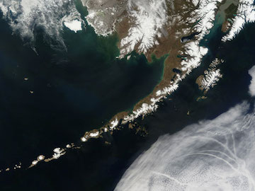
The Aleutian Islands and the Alaskan peninsula are shown in this image acquired by the MODIS on the Terra satellite, on May 25th, 2006. Credit: NASA
The Aleutian Islands form one of the most geologically active regions in North America. The island chain, which stretches westward from Alaska, is home to two dozen active volcanoes. And since the start of the 20th century, it’s been the epicenter for more than 30 earthquakes of magnitude 7.5 or stronger.
The source of all that rumbling begins well to the south of the islands, on the floor of the Pacific Ocean. Two of the plates that make up Earth’s crust are ramming together: the Pacific and North American. The Pacific plate is thinner and denser, so it plunges below the North American plate.
As the Pacific plate dives into the mantle below, it creates a deep notch in the ocean floor — the Aleutian trench. It’s up to five miles deep, and stretches for about 2500 miles — from Alaska to Russia.
The plates are moving at a relative rate of about three inches per year. The leading edge of the Pacific plate melts as it enters the mantle, creating a pool of unusually hot molten rock. Some of that rock punches holes in the overlying crust, creating the Aleutian Islands and their volcanoes.
In some places, though, the plates jam together. But they’re still pushing at each other, which creates tension. Eventually, the sticky area snaps and the plates lunge forward, creating earthquakes. The quakes can cause damage on the islands, and create tsunamis that race across the Pacific Ocean, endangering Hawaii, California, and other regions — danger from a shoving match below the ocean floor.
