361215-tragic discoveries.jpg
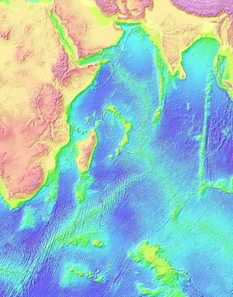
Atlantic/Indian Ocean seafloor topography from satelliet altimetry in 1997. Credit: National Oceanic and Atmospheric Administration
Most of the ocean floor is more poorly mapped than the surfaces of the Moon or Mars. That fact has been highlighted by the search for Malaysian Airlines flight 370, which vanished in 2014. Investigators concluded that it crashed into the southern Indian Ocean. But the search was hampered by the lack of good maps of the ocean floor.
That poor view hinders research as well. The contours of the ocean floor guide currents, and they affect the way different layers of water mix together. So good maps help scientists develop better models of ocean circulation, climate change, and more.
The best maps are made by ships. But only a few have scanned the southern Indian Ocean. Those cruises took place in the 1960s and ’70s, using technology that wasn’t as good as today’s, and they scanned only a small part of the ocean floor.
When the search for flight 370 began, scientists used observations from satellites to fill in some of the blanks. The satellites measure small differences in the elevation of the ocean surface, and scientists use those ripples to determine what’s below. But that reveals details that are no smaller than a few miles across.
The search itself is improving those maps, though. Search teams use sophisticated sonar to scan the bottom. The scans produce 3-D maps that show details only a few feet across. The first few months of the search revealed extinct volcanoes, tall ridges, and depressions almost a mile deep. Continued mapping should reveal much more about our planet’s hidden surface.
